Thursday, April 2, 2009

Torreys Peak (West ridge), 14,267 Ft. - Jan. 17, 2009

Everyday life is full of people just waiting to explain to you what's holding them back and why they can't accomplish their endeavors, you don't find these people climbing mountains. Just like any other walk of life, the people who share a love for this kind of adventure have common traits. Traits like fortitude, perseverance, words that you see on walls of an HR manager's office. Fortitude is a concept I came to know well on a winter ascent of Torreys peak from Loveland Pass. I can't brashly say that yet again, against the elements, I fought my personal limits and pushed through because I'm strong or because I'm that kind of person. Instead, for the first time I found myself in a situation that I knew afforded me no choice but fortitude. I know it now and I knew then, I was in deep and there was only one way out. I'll quote myself in a post I made soon after this trip.

"At times while being faced with decisions that carry very final immediate consequences you perform at the peak of endurance, mental strength, nirvana."


A week to the day after my trip up Quandary, I was feeling confident, weather was good and I was back to the top of Loveland Pass to finish what I had started. Now a standard, I was at the trailhead before the sun, met by few with the desire to trek through the elements in pursuit of proving that it can be done. I've been asked "Why don't you just jump out of an airplane?". This is like asking a painter "Why don't you just take a picture?", as if the motivation for painting a picture is merely documentation. Mountaineering is personal experience, providing clarity of mind, extending your palette, opening your senses to the appreciation of things which can't be provided at will, intangibles that are earned.


Setting out before sunrise, I made my up the Western edge of Point 12,850 with a feeling of familiarity. The slow grind of a nameless ridge to a nameless summit. The kind of place that makes for a wonderful accomplishment for the wife and kids on a Sunday afternoon, surrounded by the beauty of the forthcoming basin and awe of the seemingly towering Grizzly and Torreys. Nearing the top, the sun began to rise over the Tenmile and Mosquito ranges lighting the tops of the numerous 14er's where other aspirations were about to unfold. With clear skies and nearly limitless visibility I made my wat first over Point 12,850, Cupid, and finally up the difficult ridge of Grizzly Peak. The ruggedness and difficulty of the terrain on Grizzly and Torreys was the price for panoramic views of snow covered ridges, the like of which I had only only ever seen in photos.


From the summit of Grizzly which in itself was an accomplishment and the turn around point for the only fellow hikers out for this journey, I could see Torreys and Grays separated from me by the quite arduous descent (and return ascent) of Grizzly's Eastern ridge. Despite being tiny in comparison to peaks of which professional climbers face, it's always shocking to get the first glimpse of a 14er and just how massive it is in the context of its surroundings.


Hidden from view in the photo and not too hospitable a place for casual photo taking is the horseshoe shaped Eastern ridge leading to the saddle between Grizzly and Torreys. Rife with cornices, mixed terrain and high exposure, the ridge is exactly what I've come to know as classic, descending around 800 ft. to the North and around 1100 ft. to the South. With at sometimes no more than a foot or two room to navigate, I found myself straddling, seated with a leg a few feet down either side. It was here I made a critical decision which could have been my last. As the ridge descended it flattened out into a broad saddle, clearly my objective. Seeing the distance required to follow the ridge as it snaked Northward then South before ending safely in the saddle, I began scanning the terrain for a reasonable path of descent which would take me to the saddle but skipping the long haul around the Northern aspect. Ultimately I chose to make a more direct descend down the steep but manageable Southeastern aspect of the bowl shaped face. About 50 ft. down I began to realize the condition of the snow, now wet from the morning sun. Looking back up my path It was clear that given the time, aspect and grade of the slope, I was descending a very likely avalanche slope. Fortunately I realized this soon after starting my descent and made quick work to regain the ridge, although the distance down that I traveled and the time it took to return are really of no consequence in terms of avalanche danger. One I was back on the ridge I tried to get a shot which would accurately reflect the exposure though a camera never does justice.


From the saddle I began to make my up the Western ridge of Torreys, loose rock and talus were the themes of the climb. A thin vein of snow worked its way from the saddle to nearly the false summit so I decided to try my luck ascending it, which now was much more stable then the talus. Unfortunately I'd left my crampons in the car due to the conditions of the snow and relative angle of each ridge I'd be climbing and so was forced to chop steps out of the snow using my axe as I ascended. All in all this wasn't much of a setback, the slope was not too steep to ascend without the crampons (otherwise I would have chosen another route) nor was chopping steps too much work. After about an hour I had made the false summit and was approaching the the summit proper.

Views from the summit were spectacular, feelings of being well above the surrounding mountains, but in this instance with the exception of Gray's all the other peaks were so far below it gave the feeling of being in an airplane. I thought it would be great to continue on to Grays but given the time, my energy level and the fact that the return would require the re-climbing of Torreys, Grizzly, Cupid and 12,850, I opted for a few photos including a good shot of Evans and Bierstadt, both being previous accomplishments, and started my descent.


The snow path which I had ascended made for a great Glasside and significantly shortened the descent time. Nevertheless as I reached the saddle and began the ascent back up the Eastern side of Grizzly the time was nearing 3:30PM I was beginning to question weather I was going to make it out before sunset. I wasn't too concerned with light as I had as packed a headlamp, rather I was concerned with at least making it to the summit of Cupid before sunset. Ascending Cupid in the dark was not a delightful prospect, having just come down this morning I knew the terrain was a little sketchy in places and this in conjunction with the amount of energy I had remaining was starting to unravel my nerves. It's hard to describe the feeling, I knew I was a long hard trip from the car and a feeling of oh fuck begins to take over. This part of the climb has been the motivation for much metaphysical introspection into my life since. Hardly in dire straights, I was in a situation that I knew was going to take a lot hard work to get back out of and if I couldn't muster the strength to do it, I was going to be left far from anyone for the night. It was time to clear the mind and focus on what was most important, getting to the top of cupid by dark, from there it was a walk out. A final solace was that if things didn't go as planned I knew that once I made it to bottom of the opposite side of Grizzly, to the West, I could bail down the Western slope towards Loveland Pass and end up in Keystone Ski area and catch a cab back to the car. These are the things that you always have to keep in mind when do this type of activity.

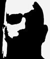
On the topic of Keystone, as I ascended Cupid, probably around 5:30 I could hear the sound of a chopper in the distance. This isn't out of the ordinary, in fact it's out of the ordinary not to hear a chopper in areas like this. It seems that there are always SAR choppers out training, saving, scouting, etc. but in this case I could hear the chopper constantly getting nearer but couldn't see it due to the setting sun in the West. Finally the sound ended but quite near to me, I was relatively sure that the chopper landed in Keystone and around fifteen minutes later up it started. This time with the sun lower I could see it taking off from the park. It was one of the orange flight for life choppers (which I've also flown on). As it left the park it headed straight East, towards me. Passing over the saddle between Grizzly and Cupid so near the ground that I surely could have tossed my axe up and hit it, close enough to see the mustache of the pilot.

Now fairly relaxed knowing that I was going to make Cupid by sundown. I did in fact but shortly after had to dawn the headlamp, making my way up 12,850 and back down to my car at Loveland Pass around an hour after dark. Reflecting on this trip is interesting because for a short time I had to make an effort to keep a level head. Not the first time I've been in a dangerous situation but the first time I was in real danger.

Additional Photos

Wednesday, April 1, 2009

Quandary Peak (East ridge), 14,265 Ft. - Jan. 10, 2009

More than a month now since my last outing the weather was looking good and I was aching to get back out out onto another climb, or walk, or trudge. I did a bit of research looking at the easier of the 14'ers for winter and Quandary is well known to be an easy and safe one in any season. That being relative. In order for a 14'er to be rated as a 14'er there must be at least 3000 vertical ft. gain from the the saddle of it its adjacent peaks to the summit. Now I don't think that means all adjacent peaks or peaks like Torrey's and Gray's wouldn't fit the bill, rather at least one adjacent peak I assume. But that's semantics. I've read some interesting discussions on the criteria for which one can say that they've climbed a 14'er, for example; It's pretty universally accepted that there must be at least 3k ft. gain and you must achieve this under your own power. So after driving to the top of Mt. Evans, then walking the 50 ft. required to reach the summit, its not fair to say that you've climbed a 14'er. How about riding your bike? Obviously the bike affords you some amount of mechanical advantage but is it traded off in carrying the weight of the bike? I can speak from experience and say that I've been on bike rides where walking would have been greatly easier than riding, so it's necessarily always easier to ride. My favorite is the question, what if someone runs on a treadmill that stores an electrical charge, doing so long enough to save up enough energy to power an electric vehicle all the way to the top? Once again I digress.

Quandary and good weather.


The weather forecast was for highs in the 30's and blustery above 13k. What is blustery? Is it winds stronger than a breeze, lesser than windy? If blustery described the conditions on quandary that day, I would say extreme wind. I arrived at the trailhead, about 9 miles south of Breckenridge and directly off the main highway so I wasn't surprised to find about 15 people there before me at nearly 8:00AM. I was getting a late start due to just not getting my shit together in good time. In contrast with climbing in the summer, when it completely typical to find no parking and a steady stream of people moving up and down from base to summit, probably nearing 200 people at a time in places like Bierstadt or Quandary. In the winter it's I find it welcoming to see others on the same climb. This drastically increases the rescue index, i.e. chances of getting pulled out if you're in trouble. So in a sense I was relieved to find some company. Again as with Grizzly, beta on this trip said to be careful with route finding, specifically in the area between the summit and the top of the first eastern slope. The standard route takes you in almost a straight line up the eastern ridge, moving too far towards the North leads into some very sketchy terrain. I read a report of a climber who on the descent moved too far North and ended up descending onto the North face. Being unable to climb back off the face he was stranded and forced to spend the night, eventually be plucked out by a chopper. knowing the topo. and now having been there I find it very had to believe that it was a mistake that put him there. On the descent, even in a whiteout keeping a few things in mind keeps you on the right path... You're always descending, the terrain is never difficult and there's a slight elevation gain to climbers right. Assuming that you get too far to the North, the inability to easily descend should be evidence that you have went astray. But after being in situation where I've lost my bearings, I hold my opinions.

After gearing up and dawning the snowshoes I began a typical steady ascent to treeline and for nearly the entire way was enjoying a very nice peaceful day.


Fortunately, or shamefully in what felt like an excessively out of shape state, the other climbers out were breaking trail for me the entire way. As I approached treeline the climb ahead became visible along with the slight indication of stronger winds above. Looking closely you can make out the other climbers on the forthcoming ridge.


Continuing upward along the South edge of the Eastern ridge views, views of the surrounding mountains were spectacular, Grays and Torrey's in the far distance.


And NorthStar with the summit of Lincoln directly behind.


As the elevation increased so did the wind, giving way to incredibly forceful gusts from the Northwest relentlessly pushing me back, pausing only briefly to spin around and push from the South causing balance on some portions of the ridge to become a concern. The continual battle against the wind was beginning to drain me physically as well a make my face uncomfortably cold. I began to pull my balaclava up over my mouth witch ultimately was a mistake as the moist air that I exhaled began to freeze into a block of ice directly over my mouth. This wasn't so much a problem of my mouth being cold but rather the problem was that the balaclava became rigid with ice I no long had the ability to alternate it between shielding my nose and my neck. Eventually I was reserved accept only cover for my moth and nose leaving my neck below the chin exposed.


As I ascended along the South side of the upper bowl which is very broad and nearly flat from North to South, the combination of wind and blowing snow made for a sight and feeling that I have never experienced. It can be be described as being in the middle of a white desert.


Continuing upward from this point became painfully difficult. By now the due to the exposure of my lower chin and now the back of my neck, I could no longer feel the difference between the balaclava which was nothing more than a block of ice, my neck and the upper chest of my soft shell. When I say this I don't mean that my chest and neck all felt cold, I mean that with my bare hand, from my chin to my collar bones everything felt like a piece of ice. Other than numb everything felt fine. The last quarter mile of the ascent took nearly and hour while fighting the wind and as the slope began to increase I found it very difficult to make every ten feet. Goals, which I typically break down into small units like, "Lets make it to that next ridge" became baby steps like "lets make it to that rock" being only three steps in from of me. In this last push I began to meet the others on their way back down, all telling the same story, "if you have anything that you need to do before the summit do it now. You wont have a chance up there." They weren't mistaken, crossing the final lip onto the summit, they winds increased two fold. To point where instinctively I felt that I should crouch way down or crawl in order to move forward. These were winds were by far stronger than any other I have ever encounter previous or since. My summit of Quandary was nothing more than walking to the highest point then immediately turning around for reprieve. Unfortunately the last picture was my final opportunity given the winds. On the descent heavy blowing snow and cloud cover made for less than a photogenic experience.

The descent was very easy, wind at my back, the weather clearing with lower elevation. I made it back to the car in about 8 hours round trip, which for many of my winter climbs was good time. Back in Denver I followed up the day with a ritual night out at the brew pub, enjoying wings and cold beer. Noticing my neck was very wet I retreated to the restroom to take a look and found that the entire front of my neck from below my chin had blistered up and the back looked like a sunburn. When all was said and done, I had moderate frostbite on the back resulting the appearance of an odd tan, and severe frostbite on the front which scabbed and sloughed off leaving a fairly gaping wound for days to come... good times.


Additional Photos